Tarleton Wood: Is this the "real" Forest Hill?
NB: These notes were originally produced in the 1990s for the Tarleton Woods Residents' Association, London SE23. They are written up here as a geographical case study, a microcosm illustrating some of the principal features of the geographic and historical development of a small but increasingly popular residential district of South London. They are currently under revision to take account of the most recent information.
The wider context of this case study is to be found in the ‘Effra in Dulwich’ page of this website. From time to time I lead Guided Walks in and around the area which are advertised in these pages: contact me by email for the latest information.
Where is Tarleton Wood?
(a) Our core area is in the SE23 postal district of South London, opposite Hornimans Museum and Gardens. It consists of Sydenham Rise, Tarleton Gardens, London Road from Horniman’s Play Park to Eliot Bank, Little Brownings, and their associated amenity areas. It is a small Dulwich Estates residential development of late 1950s/early 1960s town houses, characterised by a leafy environment, extensive views, easy access to central London, a distinctive history, and shared community interests, as represented by the Tarleton Wood Residents’ Association. (b) The adjoining parts of SE 23, including Eliot Bank, Horniman’s Museum and Gardens, Sydenham Hill (to upper Kirkdale and Cox’s Walk), and London Road (from Woodvale to Honor Oak Road) are included as being directly connected to our neighbourhood and having similar characteristics. (c) Other nearby localities, such as Taymount Rise, Central Forest Hill and Perry Vale, Lordship Lane from Wood Vale to Dulwich Common, Dulwich and Sydenham Woods; Lapse Wood Walk and Cox’s Walk also feature, whilst Upper Sydenham and Wells Park, Westwood Park and Honor Oak, parts of Dulwich, Upper Norwood and Crystal Palace are also considered where they have played a significant role in the development of our neighbourhood.
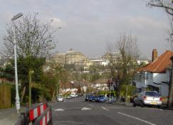
Hornimans from London Rd: Sydenham Rise and Eliot Bank join from the right, with Tarleton Wood between them
What do the local names tell us about our area?
Forest Hill is not an ancient name: it first appeared in the early 1800s (referring to the wooded Eliot Bank/Westwood/One Tree Hill ridge), but only came into general use with the renaming of the former ‘Dartmouth Arms’ railway station in mid-century.
Sydenham is recorded as Suppenham and Sidnum in the 15th century, but the origin of the name is not clear – one suggestion is that it comes from Sipa, a ‘drunken man’!
Sydenham Rise appears on early 19th century maps as a lane linking Sydenham Hill and the Great North Wood with the centre of the parish of St Mary’s Lewisham (then in Kent) via Perry Street/Vale.
Tarleton Gardens possibly records Richard Tarleton, one of Edward Alleyn’s theatrical circle, but the street name was a creation of Dulwich College Estates in the 1950s. Tarleton Wood behind is only a vestigial reminder of the ancient Great North Wood of Surrey.
Little Brownings takes its name from nearby parts of Dulwich Woods leased for timber and charcoal burning in the 18th and 19th centuries, (possibly derived from ‘burnings’?).
Eliot Bank records the hedge-bank marking the ancient boundary between the parishes of Camberwell and Lewisham – Eliot was the family name of the 19th century Earl of St Germans who bought and developed land in what became Upper Sydenham and Forest Hill.
London Road became important in the 19th century when horse drawn buses (later trams) linked Stanstead Road (Stanyhurst Street, ‘the stony clearing’) and Perry Vale (low marshy ground with pear trees) directly with London via the Plough, Dulwich. It was the lowest and shortest of only three routes across the high Sydenham ridge.
Dartmouth Road and Devonshire Road celebrate 19th century peers who were important local landowners.
Horniman’s Museum was the gift to London of Frederick Horniman, the 19th century tea merchant who lived on the site at Surrey Mount, with its fine views.
Honor Oak was named after the oak tree at the site of Elizabeth I’s picnic with one of her courtiers, Sir Richard Buckley of Lewisham.
Westwood Park was originally the wood on the western edge of Lewisham parish. Dulwich may have been derived from the dill flower (Dilwysshe) that grew amongst the water meadows in the bottom of the Effra valley. Effra may be derived from Heath Row Farm in Brixton (or possibly = Welsh yffridd, a fast-flowing stream). Also compare Etherow Street in East Dulwich.
Lordship Lane ran along the border between the lordships (manors) of Friern (Peckham Rye) and Dulwich. It had its own railway station (on the old High Level line linking New Cross with Crystal Palace) until 1954.
Wells Park in Upper Sydenham is on the site of the chalybeate wells developed as a fashionable spa in the 18th century. King George III visited at least once when his troops took part in manouevres here. At Dulwich Common were located Dulwich Wells. Here ‘The Green Man’ (later ‘The Grove Tavern’) was named after a woodland sprite in popular folklore. The 18th century pub landlord gave his name to Cox’s Walk. (Dr Glennie’s Academy attended by the young poet Byron was also located there).
Upper Norwood takes its name from Surrey’s ‘Great North Wood’,
which separated the burgeoning Metropolis from rural Kent and Surrey
until late Victorian times. The Wood with its steep slopes and watery approaches had few permanent
residents until it became the site of Joseph Paxton’s relocated Crystal Palace
in 1854 Gipsy Hill in Dulwich reminds us that it was a seasonal home for charcoal burners, woodsmen and
graziers, and a notorious refuge for immigrants, hermits and criminals,
including ‘Brockley Jack’, a local footpad, and gypsy Queen Margaret. Note the many local ‘spring’ , ‘hill’, and ‘wood’ names in and around Forest Hill; also Belvedere, Beaulieu (Beulah), Belvoir, Beauval etc., all advertising the virtues of the wide vistas and healthy ambience of the area to London's growing middle classes.
The Real Forest Hill: Physical Environment
(a) Relief and drainage:
Tarleton Wood is located on the northern flank of Eliot Bank, where it slopes down from an altitude of 105 metres (330 feet) on Sydenham Hill to 75 m (250 ft) at London Road. It is part of a narrow 8 kilometre (5 mile) ridge whose highest point is 110m at nearby Crystal Palace. This ridge once hosted the eastern part of Surrey’s ‘Great North Wood’ which extended in an arc from Streatham Common in the south-west, to One Tree Hill and Nunhead in the north-east, and has always formed an obstacle to easy movement in and out of south and south-east London. London Road is the lowest and shortest of only three roads that cross the ridge to link London with Kent; railway lines had to tunnel through. The steeper slopes and the skyline from Eliot Bank to One Tree Hill are still predominantly wooded when viewed from either side of the ridge, hence the name ‘Forest Hill’.
Tarleton Woods and Eliot Bank from above the Hornimans saddle The Dawsons Heights 'ziggurat' from Westwood Park
Northwards our area looks beyond Dawson’s Hill and its flats (sometimes likened, rather unkindly, to a huge cruise ship or an Assyrian ziggurat!) towards Central London and the City, and north-westwards across Dulwich Common towards Battersea and West London. It includes occasional springs that once fed the River Effra (a former tributary of the Thames in Lambeth), part of a spring line at about 80 m along the whole length of the ridge.
Tarleton Wood & Eliot Bank overlook Hornimans Play Park, with a boggy spring in the foreground, and springs in the Wood too
Springs rising on the other (south) side in Taymount Rise and Wells Park, Sydenham, drain east to the Pool river and the Ravensbourne at Catford. London Road takes advantage of the lowest saddle (75 m) that directly crosses the ridge, which is also at its narrowest here. Though technically a ‘dry’ gap (no stream passes right through it), both Tarleton Wood and Horniman’s Gardens had springs (the latter fed an attractive water garden until the recent Museum expansion), with the result that the roads flood frequently, and the Play Park is often boggy. Small ponds and intermittent streams survive in Sydenham Hill Woods to the west and are shown on old maps in Honor Oak Park to the east. There is better drainage on the lower, gentler slopes, but surviving ditches, ponds and open spaces mark former water-courses and meadows in Dulwich and Peckham to the north, and Sydenham and Penge to the south.
(b) Rocks and resources:
Sydenham Hill forms the southern rim of the inner part of the geological London Basin (the equivalent of Hampstead Heath on the north side). The rocks were deposited as muds in the rising Eocene sea that flooded the Basin about 8m years ago – mainly impermeable London Clay resting directly on the Chalk that rises southwards to be exposed today as the North Downs. London Clay is normally stiff, wet and yellow-brown when first exposed, but when it dries out it cracks and weathers easily and becomes crumbly. It includes localised sandy lenses and limey bands, and on Sydenham Hill it is capped by permeable sands and gravels, a local aquifer that fed the springs at the clay junction below, and was utilised for public water supply until recently. These gravels are the source of many of the flint and chert pebbles we find in our gardens. There are a few fossils, mainly bivalve molluscs, and casts and impressions of small invertebrates and plant remains.
The clay was used locally for brick-making, producing South London’s typical yellow house bricks, or the coarser blue-black bricks found in Tarleton Wood. Brickworks survived on the slopes of nearby Dawson’s Hill into the 20th century. The bricks were fired originally with charcoal that was produced extensively from coppiced trees in the Great North Wood. Many of the notorious ‘gypsies’ who camped in the woods were charcoal burners or ‘colliers’ (hence ‘Gipsy Hill’, ‘Giles Coppice’ , and 'Ling's Coppice' in Dulwich, and ‘Colliers Wood’ further west; it is also possible that ‘Little Brownings’ records these ‘burnings’). Charcoal-smelting survived until the late 18th century, until ‘sea coal’ from Northumberland and South Wales could be brought in cheaply via Deptford Creek and the new Croydon Canal (see History section below). Because of the ‘Hilly Fields’ near Nunhead locks were necessary at Honor Oak Park, and a holding reservoir was provided at what is now Sydenham Park so that the Canal water didn’t drain away. The Canal was drained in 1830 and replaced by the world’s first public railway, which briefly became an experimental ‘atmospheric’ (compressed air driven) railway, and finally the commuter line which literally put Forest Hill on the map.
(c) The soils
Gardening in our area is not straightforward. The north- and north-westerly aspect of our slopes, and their steepness, mean that the soils do not warm up readily, because the sun’s rays (coming from a southerly direction) strike northerly slopes at a low angle, reducing their heating effect. The tree cover also filters out much sunlight. Clay soils, especially when wet, are naturally ‘cold’ soils anyway, so the combined effect is that the soils warm up and dry out slowly in the spring. They are heavy and cloying after rain, and prone to constant soil creep and occasional slipping and slumping. This produces undulating ground, and variable slopes. Shrinkage occurs in summer and cracks frequently open up along the edge of the Woods. The resulting subsidence has necessitated the underpinning of many houses in Dulwich and Sydenham. Swelling occurs in winter, causing sudden slips and slumps. These problems seem to be increasing: witness the bulging, leaning and cracking of retaining walls along Sydenham Rise.
The soil is black or dark brown, grading to mid- or grey-brown in colour, with a well-mixed mull (non-acidic) humus layer; there are no sharp A-B horizon (soil/subsoil) boundaries, reflecting the Wood’s former garden status, but there is much woody litter and fibrous organic matter resulting from its more recent growth back to woodland (as well as from unfortunate and sometimes indiscriminate dumping of garden rubbish!). The surface is often highly compacted, producing puddles on well-trodden grassy areas. Soil texture is generally classified as clay or clay loam and the soil pH is typically 5.5 to 7. This neutral, clay-rich and easily weathered soil, with its rapid recycling and incorporation of nutients, is generally favourable to deciduous tree and shrub growth, but the water-retaining ‘blocky’ structure and low heat conductivity of clay soils is not so conducive to bulb, flower and vegetable gardening.
(d) Climate and weather:
Temperatures: The atmospheric mean is some 2 deg C above the average for southern UK, due to the ‘heat island’ effect of the Metropolis (a combination of high rates of absorption of the sun’s rays by buildings, roads, etc., and internal heat generation by traffic, industrial processes, central heating and air conditioning units). Mean daytime temperatures range from 5 deg C in January to 20 deg in July, but extremes of -8 deg and +33 deg respectively have been recorded. There is quite a long growing season – 40 weeks or more, between March and December – resulting from a relatively early spring, and a long, late autumn; grass grows intermittently throughout the year.
Local weather and micro-climate is controlled by altitude, slope (particularly in relation to wind direction), aspect, ground cover, soil type and so on.
Sunshine: There are considerable local variations in duration and intensity, mainly due to slope, aspect (direction faced), and amount of tree cover. Sunrise tends to come late, but sunsets are often long because of the extensive and relatively low views and open aspect in the Thames Valley to the west, and colourful because of the extensive layer of dense, polluted air that often sinks over the Metropolis by the end of the day.
Relative humidity is a little higher than the London average– a response to a high incidence of surface water on the impermeable clay soils, the north-facing aspect (which slows evaporation rates), and the degree of shelter and shade given by tree cover.
Precipitation totals are low for UK (and NW Europe!): 450 to 500mm per year (this would make our climate semi-arid by some classifications!). It comes mainly in the form of drizzle and light rain, but showers and thunderstorms can produce heavy runoff at any time of the year, especially on footpaths and other eroded surfaces, and on roads and driveways. Snow is rare (4 or 5 days a year, mainly between January and March, and it rarely settles).
Ground frost and radiation fog are also infrequent (20 to 25 days a year, mainly early in the morning, and rarely lasts all day except in very sheltered, shady spots), but hill fog (low stratus cloud) occurs in winter on Sydenham Hill, and there is often cold air drainage downslope in Honor Oak and Dulwich, especially in the evenings.
Wind direction is mainly from a south-westerly quadrant, reinforced by channelling parallel to the Sydenham/Forest Hill Ridge; most of our weather comes from that direction. Tarleton Woods are sheltered by Eliot Bank and Horniman’s from south-easterly winds, which often bring the more extreme temperarure contrasts between winter and summer, but northerlies and north-westerlies (which are often stormy) are exaggerated by the open aspect in that direction.
NB 1: The weather described above mainly relates to Tarleton Woods and Hornimans on the London side of Forest Hill; it is often quite different on the Kent and Surrey side, which faces south and east and is therefore warmer and drier, at least during the day.
e) Vegetation:
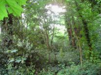
NB 2: Tarleton Wood is not primary or climax vegetation (a stable response to prevailing climate and ground conditions built up over centuries without interference), since the trees and their products have been cropped, managed and altered since the Middle Ages in response to local and London-based demand. From the mid-19th century to the first half of the 20th it was occupied by large middle class Victorian houses and their gardens, so it is classed as secondary woodland (periodically managed and modified), or even tertiary vegetation (cleared, and newly planted with often alien species). It is therefore only an indirect descendent of the Great North Wood that once clothed the Forest Hill ridge.
Woodland structure and composition: :
1) Canopy layer of large mature trees: mainly sycamore, hornbeam, oak, ash, horse chestnut, lime ...
2) Second storey tier of smaller trees and saplings: including holly, yew, rowan, hawthorn, alder, alder, apple, pear and cherry ...
3) Shrub and seedling layer: rhododendron, briar, bramble, laurel, dogwood, privet, ...
4) Flowering plants: wood sorell, bluebell, ransons, nettle, dog mercury, ragwort, herb robert, sweet woodruff ...
5) Herb layer: grasses, sedges, juncus rush, primrose, anemone, pimpernel, dandelion, celandine, ground elder ...
6) Soil layer with fungi, ferns, mosses, lichens, algae ...
7) Climbers: especially ivy, clematis (old man's beard) and
8) Epiphytes: mistletoe?
f) Organisms and ecosystem:
NB 3: The following is based on an informal inventory of creatures observed and recorded between the early 1980s and the mid-'noughties', and is not to be regarded as a controlled scientific survey.
(a) Birds – mainly hedgerow and garden birds, with some woodland species.
Residents: wood pigeon, lesser spotted woodpecker; robin, nuthatch, dunnock (hedge sparrow), wren; blue tit, great tit, long-tailed tit, coal tit; blackbird, song thrush; carrion crow, magpie, jay.
Visitors and seasonal migrants: collared dove, feral pigeon; chaffinch, ; tree creeper; green parakeet, redwing.
Occasionally seen: racing pigeons; green woodpecker; greenfinch (in cold weather), golden oriole; sparrow-hawk, little owl; overflying mallard ducks, barnacle geese, and herons; common and black-backed gulls; swallows, swifts and martins; spotted flycatcher, pied wagtail, bullfinch and goldfinch. House sparrows and starlings were formerly resident but are now rare.
(b) Mammals and amphibians: urban foxes (some resident); grey squirrels. Hedgehog (now rare).
Brown rats, mice, shrews and voles; bats; common frogs, occasional newt and toad.
(c) Invertebrates (selected species): (i) Insects: solitary bees (including bumbles), honey bees; wood wasps, common wasps, occasional hornet.
Ladybirds - 2 to 6 spot natives, + recent invaders (larger, more spots); colorado beetle.
Other beetles – carnivorous (eg Devil’s coach-horse), wood-eating (eg Stag beetle), plant eaters (eg cockchafer), scavengers (ground and dung beetles).
Flies and pests: hover flies; aphids (green-fly, black- and white-fly), midges, gnats, mosquitoes, crane fly (daddy long legs), earwigs, house flies, blowflies (bluebottles); black and red ants. May flies, dragonflies; lacewings; grasshoppers. Woodlice, centipedes, millipedes. House and garden spiders (including zebra and jumping varieties)..
Butterflies and moths: small tortoiseshell, fritillery, comma, large white, common blue, skipper, red admiral (all decreasing); moths include small brown, lime hawk moth, Jersey Tiger moth (recently colonised from New Cross?).
Earthworms, slugs and snails.
(Awaiting revision)
f) Environmental change:
There are some relict features of changes in the distant past, eg the Ice Ages of the last 2 million years (when our area would have had Arctic tundra conditions while the rest of Britain was occupied by ice), punctuated by ‘Inter-glacials’ when the climate was often warmer than today. The plateau gravels on the top of Sydenham Hill and the steep irregular slopes below them may well be a product of periglacial processes (governed by frost and meltwater action rather than glaciers), while some ‘brickearth’ soils which helped to establish south-east London and Kent as ‘the Garden of England’ (similar to the wind-blown loess soils of Central Europe and Asia) also date from that time. The environment and characteristics of the oak and hornbeam forest of the Great North Wood would have been forged when the soils and climate warmed up after the thawing of the last UK glaciers about 10 000 years ago, and when the present day drainage pattern first established itself on new and often unstable slopes (see ‘The Effra in Dulwich’ page of this website). More recently, in the ‘Little Ice Age’ from the 13th to 19th centuries, winters were colder and stormier than today: pools and streams often froze over, and snow and frost were more frequent and longer lasting.
Recent environmental changes in our area mainly stem from the direct and indirect effects of deforestation and land use change, and the revolutions in urbanisation and transportation: increased surface runoff and consequent lowering of the water table, changes to air quality and visibility, increased wind speeds, changes to the nutrient status, structure and texture of soils, increased slope instability, and loss of plant and animal habitat.
Future changes could well result from global warming, whose effects are as yet uncertain, but there are already signs of substantial recent changes to our local wildlife and plants, for example the dramatic rise in numbers of non-native green parakeets and Jersey Tiger Moths, and the loss of starlings and sparrows. However, there is an alternative scenario which suggests that there may be a return to colder conditions in Britain, as a result of changes to the North Atlantic oceanic circulation and its accompanying Jet Stream.
The Real Forest Hill: History:
(a) Early times:
Old OS maps show burial mounds near Firemans Alley, and traces of Iron Age banks and ditches on Dawson’s Hill (East Dulwich), possibly supporting an unverified local tradition of Roman soldiers gathering here at the time of Boudicca’s Revolt and March on London in 69 AD/CE. There is also an intriguing alignment of Stane Street, the Roman Road from Lewes and the South Coast to London, via Addington and West Wickham, Sydenham, Forest Hill, and Southwark.
(b) Medieval and Tudor times:
Sparse anglo-saxon and medieval hamlet and farm settlement developed on lands owned by the Abbots of Bermondsey and Battersea, while Croydon became an important summer retreat for the Archbishop of Canterbury. Villages grew up under church and manorial protection and influence, a focus for the Parishes of Lewisham and Camberwell that met at what is now Forest Hill, and for those of Croydon, Beckenham, and Battersea (which owned Penge), and met at The Vicar's Oak in Upper Norwood. Likewise, the Manors of Dulwich, Friern (East Dulwich), Sydenham, etc. nurtured smaller settlements in between, as is evidenced by continuing local boundaries along Lordship Lane (between Dulwich and Friern), Westwood Park, Eliot Bank and Sydenham Hill (Camberwell and Lewisham), and Vicar’s Oak (Camberwell, Lambeth and Croydon), among others. Old parish boundary markers are still to be seen at the top of Kirkdale and near Forest Hill Road in our area.
In the Middle Ages the Great North Wood of Surrey (along the high ridge running in an arc between Streatham in the west and Deptford in the east) became important for its timber cutting and other forest products, and for charcoal burning, serving the growing town of Croydon and the City and Port of London. However, it was also an effective boundary between the commercial spheres of influence of the two centres. Meanwhile Peckham Rye, Dulwich Common, and Penge Common became important grazing and fattening areas for livestock being driven up from Kent and the Weald to be sold in the markets around the City and along the Thames. Sydenham was increasingly well known for its fruit trees (particularly pears, as in ‘Perry Vale’), Dulwich for its herbs (eg the ‘Dill flower’ that may have given Dulwich its name), and Camberwell, Peckham and Nunhead for their vegetables and fresh milk. London, Deptford and Greenwich become important magnets for population, trade and industry, especially with the rise of shipbuilding and mercantile trade in Tudor times, such that timber cutting had to be increasingly regulated in the south-east of England, a considerable setback in our area. After various visitations of the Plague in London, and Henry VIII’s Dissolution of the Monasteries (1536), monastic and manorial influence declined in the countyside south of London, as new land-owning family estates appeared and spread, often under Royal patronage.
(c) Elizabethan to Georgian growth: [Notes undergoing expansion and incorporation ...]
Queen Elizabeth picnicked under the 'Oak of Honour' while visiting one of her courtiers, Sir Richard Buckley of Lewisham; One Tree Hill may well have been the site of one of the early chain of signal beacons giving warning of the Armada invasion by the Spanish fleet (1588). Edward Alleyn (actor and Theatre Manager) acquired the Manor of Dulwich on the death of his father-in-law, Sir Thomas Calton, and used it as the site of his 'College of God’s Gift' - almshouses for the poor, and and a school for twelve poor scholars (later Dulwich College). Inclosure Acts led to the flight of poor labourers and cottagers from the countryside; the first conservation legislation replaced deforestation in the Dulwich Woods by coppicing (sustainable management). Rumours that plague pits were dug on the space occupied today by the Horniman Triangle and Play Park in the 17th century are unproven.
[Coaching era (Thomas Tilling etc): growing influence of London - early commuting by gentry from country retreats (footpads?), hauliers and traders along toll roads; horse rearing, pigs, dairying and market gardening, esp in Dulwich.
Roadside hamlets join up, becoming commuter villages: Dulwich, Lewisham, Lower Sydenham, West Wood. Deptford Creek? Dulwich and Sydenham Wells – Green Man (Grove/Harvester - Dulwich Wells)), Greyhound, Plough, Woodman; Sydenham Hill.
Wooded Sydenham-Forest Hill ridge still a major obstruction and boundary zone between encroaching London metropolis and predominantly rural Kent and Surrey: ‘green lanes’; charcoal burning; colliers and gypsies. Brickworks, sand and gravel pits spread. Dr. Glennie’s Academy.
(d) Canal and Railway era (1800 to 1914):
Transport Revolution stimulated ribbon development of middle class building, commuting and associated services. Croydon Canal, then Surrey Iron Railway, London and Croydon Railway (including atmospheric railway experiment) > Dartmouth Arms (Forest Hill). Crystal Palace High Level Railway (Lordship Lane Stn). Horse-drawn buses (Tilling) to Dulwich Plough, then tram routes to Forest Hill via Horniman’s and London Road stimulated lower middle and working class development. Dissenting and RC Churches, and new (daughter) parishes either side of the Hill: St Paul’s, Holy Trinity, St Augustine’s, St Philip’s, St Peter’s, St Stephen’s etc. Developing German community, with church in Taymount Rise. New Parks and open spaces: Dulwich, Horniman’s, Wells Park, Crystal Palace, One Tree Hill, Nunhead and Camberwell Cemeteries, Honor Oak covered reservoir, Peckham Rye, etc. Forest Hill Library, and Baths. Shops, Schools and Churches come and go. Farms and large estates broken up and sold off for house-building, smallholdings dwindle.
(e) Consolidation and change: 1914 to 1960:
Motor transport; buses; Crystal Palace fire 1936 > closure of High Level line and Lordship Lane station in 1954 (replaced by extension of 63 bus route from Honor Oak). Payne’s Fireworks at Honor Oak Park bombed (1944?)– becomes allotments. Bomb damage and slum clearance > New ‘Council’ estates, big old houses demolished, converted or subdivided – including Eliot Bank Estate, Sydenham Rise, Sydenham Hill Estate, Dawson’s Heights, etc. Sydenham Girls, Kelvin Grove schools etc established. Conversion of old houses to Care Homes etc. Sydenham Children’s Hospital comes and goes.
(f) 1960 to New Millenium:
South Circular Road: Sydenham Hill/Woodvale lights etc. Highwood Barracks and 'Green Godesses'. Horniman’s expansion. London Wildlife Trust Nature Reserves in Dulwich Woods and Devonshire Road. ABC Capitol becomes Bingo Hall. Shopping decline: fast-food outlets proliferate. Eliot Bank, Fairlawn, Horniman Primary Schools built. St Peter’s parish merges with St Clement’s East Dulwich – church becomes ecumenical urban ‘monastery’, then Black Community Church. St Paul’s Church > Holy Trinity, St Augustine’s church closes, then reopens. Neighbourhood Watch and Community Policing starts, Tarleton Woods and Little Brownings Residents’ Associations, and Friends of Horniman’s established. New legislation relating to Leasehold and Charitable status – consequent changes to leasehold status and rules, and Dulwich Estates Management Scheme. New P4, P13, 356 bus routes. 1976 drought and 1987 storm damage.
(g) Recent changes:
St Paul’s church now closed. Horniman’s redevelopment and expansion. Transport for London: Red Route, bus lanes, traffic management schemes in London Rd, Sydenham Rise and Honor Oak Rd. Swimming Pool and Library refurbishment, ‘Concrete House’ in Lordship Lane rescued. Retail changes; PO relocation; Sainsbury’s and Car Park redevelopment, MacDonalds closes; Highwood Close; Green Chain Walk along HL railway. ‘Overground’ reorganisation of FH railway service. Capitol Bingo becomes Wetherspoon pub. Forest Hill Society established. New business units and apartments along railway behind Dartmouth Rd, community amenities at Forest Hill and Sydenham Schools. ]