Ebbw Vale: Industrialisation and After: a South Wales Geographical Case Study (condensed)
Location: Ebbw Vale is the industrial, administrative and retail centre of the Urban District of Blaenau Gwent, in the NE part of the South Wales Coalfield Industrial Region. It lies just S of the ‘Heads of the Valleys Road’ (A465(T) - 15 km E of Merthyr Tydfil, the same distance W of Abergavenny, and 30 km N of coastal city of Newport, Monmouthshire (fig. 1 ).
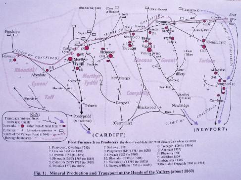
Site: Where River Ebbw fawr, rising at 500m on Millstone Grit rocks on Mynydd Llangynidr (part of the Brecon Beacons National Park 5 km to N), and following the SSE dip of the rocks, crosses a strike vale excavated in less resistant Lower Coal Measures (see fig. 2 below). Small tributaries join from east and west at the foot of a prominent scarp marking the northern rim of the former* Coalfield (part of the ‘Heads of the Valleys’ corridor (2) from Hirwaun in W to Clydach in E. The strike vale provided the only easy link between parallel deep steep-sided tributaries of the Rivers Taff and Ebbw which dissect the Coalfield southwards. The Beaufort ironworks was located here, at the N end of Ebbw Vale.
Geology and relief: The Ebbw fawr river continues south and enters funnel-shaped mouth of the ‘Vale’, deeply incised into Lower and Middle Coal Measures. These contain most of productive coal seams and nodules of ‘blackband’ iron ore (high-grade haematite, 40-50% iron) that made Heads of the Valleys the world’s first Heavy Industry Region. The coal wass good quality, hard and bright, bituminous, and used for coking and household use. Seams vary from a few cms to two metres thick, 10% of the total formation from coastal swamp forests 280 m years ago, sandwiched between layers of sandstone and shale representing marine transgressions that buried and compressed them. Geological faults from subsequent uplift frequently interrupt seams; water percolates readily through the sandstones along joints, making frequent pumping necessary underground. The Upper Coal Measures have few seams, but are capped with resistant Pennant Sandstone, used for building (3).
Ebbw Vale is one of six deep valleys flowing S only 3-4 km apart. They were superimposed from a former gently sloping surface onto a synclinal (saucer-shaped) structure of rocks beneath (fig. 2). But the rocks underground dip more steeply than the slope of ground surface, so southwards most productive coal seams were found at ever greater depths beneath valley floors (4), requiring costly and dangerous deep mining. The Valleys became narrower and deeper towards the upturned southern rim of the syncline near Newport (the streams flow against dip of rocks here (5)); their rivers are stony and fast-flowing, variable in gradient, and rarely navigable.
The Valleys provided relatively easy movement down to coast, but it was slower and more difficult northwards. There are few tributary valleys in the Coalfield, so movement was almost impossible westwards and eastwards - hence the importance of the ‘Heads of the Valleys’ corridor.
To appreciate steepness and height of valley sides consider this: the river is below 300 m above sea level (900 ft) in EV town, but the ridge above only 1 km to W is 500m high (1550 ft), and to E is 550m high (1700 ft). No roads connect with other valleys for 9 km (6 miles) between EV centre and the Ebbw fach confluence at Aberbeeg; also no access roads or settlements adjoin main road for the next 4 km (2 ½ m) south of Cwm.
* Coal mining effectively ceased within the Coalfield after the 1984 Miners' Strike.
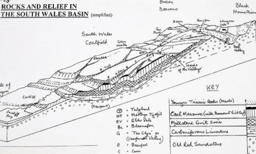
Fig 2: Simplified Geological Section from the Black Mountains to Cardiff Bay
Environment and Resources: Little flat land in valleys, narrow floors often flood. Rivers formerly heavily polluted, but now improving. Poor glacial soils, slopes steep and/or unstable near quarries, tips and springs. Valley sides originally oak, ash and birch woods, now more often scrub, bracken, conifers, or derelict; higher up poorly drained grazing land.
Upper slopes and interfluves exposed to rain-bearing SW winds > cool damp climate. Temperature inversion in valleys often limits vertical mixing of air > frost, smog, and lung disease. Iron and coal resources , + building materials (sandstone and aggregate; clay and silica for brick and tile making); limestone quarried just to N (dip slope of Brecon Beacons scarp) – formerly for fertilizer and blast furnace flux, now mainly for cement, building, railway ballast, road metalling. Water is important secondary resource, esp from Brecon Beacons to north.
Ebbw Vale’s Industrial and Settlement History.
 Fig 3: The industrialisation and growth of of Ebbw Vale (diagrammatic)
1. Pre-industrial base – V. poor semi-subsistent upland livestock farming > sparse hamlet and farm pattern; transport at speed of horses and carts along tracks and poorly maintained roads. Isolated: local markets at Brynmawr and Tredegar, and down valley at Abercarn. Some small forges and furnaces produced wrought and cast iron for local use – mainly tools for farmers, farriers, hauliers etc.
2. Primary production and bar iron phase – Local Raw Materials plus fast-flowing water, cheap land etc led to Blast furnace Iron smelting at Beaufort in 1779 (linked with Sirhowy works near Tredegar) at Head of the Valley, then one mile down Ebbw Vale itself (Victoria works) in 1789. Charcoal-fired at first, then coke-fired, producing pig and bar iron mainly for working up and finishing elsewhere. Industrial housing thrown up around each works, then spreading to the road junctions between them (the modern A 4047; the A 465(T) did not exist until 1930s). Site constraints encouraged archetypal ‘rows’ parallel to contours on lower valley slopes as demand for housing increased, then ribbon development along the valley roads producing an elongated ‘T’ shape. Some local intra-industry links (horizontal not vertical integration), markets in Wales, England and overseas accessed mainly via Head of Valleys W to Merthyr, and E to Brynmawr/Abergavenny because of poor transport southwards. Tramroads (eg the Brinore Tramroad at Talybont) often built by canal companies to give lower cost access to markets by navigable water – eg the Brecon and Monmouthshire Canal.
3. Iron manufacturing phase – 1830s to 1860s - Railways (1830 onwards) changed things dramatically: they were quicker, more direct, easier to build and maintain, and used cheap local coal; > down valley development. Rapid increase in demand for cast iron sheets plates and rails, and coal for railways and steamships - especially for overseas markets after the Napoleonic Wars - led to increasing scale and volume of iron and coal production, and shipment direct to Newport. Some iron ore being imported up valley from overseas – cheap to buy, but costly to transport. Victoria works now had relative advantage over Beaufort etc, therefore the Vale becomes dominant for production and settlement – ironworks, collieries and railways in bottom of valley; improved roads, terraces along lower valley sides, served by chapels, meeting halls, schools, shops and a market. Population c 4-5000?
4. Bessemer steel-making phase – 1860s to 1930s – Large volume partially integrated iron and steel industry: “convert to steel, or perish”. Half H of V sites closed straightaway, including Beaufort, but Ebbw Vale, Dowlais, Blaenafon, Cyfarthfa (Merthyr), Tredegar and Rhymney survived using Bessemer converters. But local ore too phosphoric for Bessemer process (until Gilchrist Thomas at Blaenafon), so now all ore imported – inland sites at comparative disadvantage to coastal ones (Cardiff, Port Talbot, later Llanwern). Dowlais works moved to Cardiff.
Ebbw Vale (Richard Thomas and Baldwin) struggled on with huge govt subsidies (social need over-riding economic sense), the rest finally closed. Bessemer steel-making expands, using imported ore and some pig iron brought in from coastal works. Continuous cold and hot strip mills expand along valley floor. Coal brought up valley by rail from new deep mines at Cwm, Llanhilleth etc.
Older rows and terraces knocked down and replaced, some infill, some new and expanded settlement on hillsides (Willowtown, Briery Hill, Glyncoed, Newtown, Waun Lwyd etc); Beaufort stagnates and becomes suburb. Cwm/Tallistown grows as classic pit village around two new deep shaft collieries. Population of valley 20,000 plus – high density ‘beads on a string’ > almost continuous ribbon development from Beaufort to Cwm for 8 kilometres (5 miles): popn density of 3ooo+ per square mile within valley, but almost empty on interfluves, and below Cwm).
5. Integrated Iron and Steel phase – 1939-1980s – Bessemer steel successively replaced by Nielsen Hot Blast, Siemens-Martin and electrolytic processes, using highly capitalised modern methods, less labour, and materials increasingly imported from elsewhere, including pig iron and steel ingots from the Abbey works at Port Talbot, and coke and scrap from wherever. Whole works 4km (2 ½ miles) long in 1980 (see figure 4), including Europe's longest single strip mill (over ½ mile). Products were mainly coated steel strip for vehicles, domestic appliances, tin plating, and galvanising.
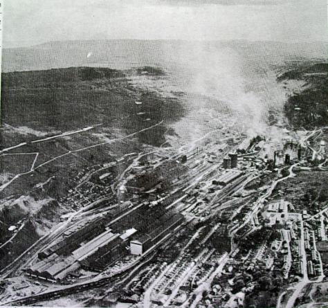
Fig 4: Aerial view of Ebbw Vale (from the north) in the 1960s
The plant was initially privately owned but heavily subsidised, then became nationalised within British Steel. Local coal and iron production ceased, including the Cwm collieries. Rail transport was replaced by road, with the A465 H of Vs road paramount (this was a 3-lane single carriageway Trunk Road from Abergavenny to Glyn Neath only fully completed in 1964; it was notoriously slow, dangerous, and often saturated or blocked.
There was ncreasing unemployment from 1918 on, reaching 25 per cent in the 1930s. Ebbw Vale was a classic single-industry town: the steelworks employed 8,000 directly (mainly men). Their amilies were also directly dependent because there was little alternative employment; shops and services in the town were indirectly dependent. The demise of the iron, coal and steel industries was catastrophic socially, economically and environmentally. The Vale was highly polluted – slag heaps were still on fire alongside the B 4468 until the 1980’s, ash and particulates filled the air producing fog, metals and chemicals poisoned water and soils; scrap metal, tailings, coal tips and iron and silica waste were widely evident, and household rubbish was often dumped indiscriminately: the environment was sterile, dangerous, unsightly.
The Steelworks closed in 1980, tinplate & galvanising in the 1990s, and most was dismantled by 2002. 6. Post-industrial phase – 1960 onwards – Environmental improvement and Regeneration:
Increased investment mainly through government agencies and EU Regional Fund.
Garden Festival 1988 opposite Waun Lwyd *, now Festival Park – new housing, factory outlet shopping, and enterprise area – limited success. Education Centre and Nature Reserve nearby.
Starter Business Area at Cwm – some road improvements south, but railway almost defunct, and south end of town struggling.
Pedestrianisation of High Street. New industrial/business area on steelworks site.
Light industrial and housing estates developing, mainly north of H of Vs Road - esp. Rassau. A465 Trunk Road: Merthyr to EV and Clydach to Abergavenny now dualled, EV to Brynmawr and Clydach (the highest, steepest and narrowest section) now in progress.
Settlement pattern and functions (see figure 3): EV is like most S Wales settlements - 19th century fabric, high density, linear/rectangular, not strongly nucleated (it grew around production sites, not cross-roads). Conventional Urban Models and concepts of CBD and Peak Land Value Intersection hardly apply+, but note my own empirical Upland Resource-based Settlement Model in Fig 4 belowl:

Fig.4: An Upland Settlement Development Model (MDK: 2004)
* means “grey swamp” in Welsh!
+ The prime site at the north end of EV’s High Street is occupied by a derelict 1960s concrete multi-storey car park, which was a listed building so it couldn't be demolished!
The former valley-bottom steelworks site still dominates settlement form, with Victorian and early 20thC terraces flanking it on lower slopes. There are
1960’s housing estates perched higher up at Garnlydan/Rassau,
Willowtown/Hilltop, Beaufort/Glyncoed. The main streets in Beaufort, Ebbw Vale, Waun lwyd and Cwm consist of low order services (pubs, cheap fast food outlets, betting shops, general stores, charity shops, chapels, hairdressers etc.) randomly interspersed with houses, vacant buildings, and derelict or unused space; there are few side streets, mainly short cul de sacs leading up to the next terrace along the valley side. Surprisingly, there is only one ‘Hotel’, and no pubs in EV proper – they couldn’t compete with subsidised steelworks social facilities. Beaufort (popn c 4000) adjoins Brynmawr, the highest town in Wales; Hilltop Estate adjoins Tredegar in the neighbouring valleys.
In the 1960s a new Blaenau Gwent Civic Centre and library was built on reclaimed land along the A 4046 N of the town, with a secondary school, Tertiary College (for vocational training and retraining), emergency services, and a Leisure Centre. Waun y Pound retail area was later built on the road leading west to Tredegar. Tesco’s Superstore dates from 1990 and has led to further decline of High Street shopping (see footnotes*). From 2004 onwards redevelopment of the cleared steelworks site led to a new Community Education Centre, Environment Campus, and Hospital, along with more enterprising eco-housing projects.
The urban population of Beaufort - Ebbw Vale - Cwm peaked at 22,000 in the 1970s; since then many people have moved out (especially the young, while many of those remaining work outside the Borough.
Future Prospects: Not great! Town growth is shifting back towards the Heads of Valleys (N end of town) –the south end is stagnating, despite Garden Festival improvements and factory outlet retailing etc. Access to A 465 Trunk Road still important, access down Ebbw valley still long and slow. EV at relative disadvantage compared with main southwards routes from Merthyr (A470) & Abergavenny (A40) to M4 and ports; it is seen as a mere halfway transit point, but current dualling of 'Heads of Valleys' road should improve that. Reopening of the Ebbw Vale Railway to passengers has proved successful (currently to Cardiff, soon to Newport), but may only encourage more people to commute or move house down valley. New short funicular railway connection built between lower Station and upper retail area to unite the town is controversial (huge cost, but low uptake).
Traditional skills not needed now, modern (mainly communication) skills slow to be taken up. Limited social and entertainment opportunities are available, especially for families and youngsters, and there is little suitable heritage or holiday potential to attract visitors. There are continuing environment, infrastructure, and fabric problems, giving an unfortunate image. How does Ebbw Vale attract new residents and jobs, and keep young families?
* In the 1980s students from Wilson’s School took part in fieldwork projects to find the best location for a possible new superstore in Blaenau Gwent, taking account of accessibility, site suitability, population, possible competition, planning controls etc. The most popular choice was a derelict site on the A4046 just north of EV centre. In 1990 Tesco bought and developed that same site. Although a vindication of the boys’ fieldwork results, it signalled the end of their superstore projects – competition was deemed too great to warrant another superstore in the District!
MDK 1995/2002/2016/2018